Higher or
Denser?
A Debate
Aided by GD on the Historic Urban Texture Conservation of a Typical Commercial
Region in Shanghai
SUN Chengyu
Campus of Architecture & Urban Planning, Tongji University, Shanghai, PR China
Abstracts:
The foreign concession period from 1840s to 1930s is the birth of modern Shanghai. And its influence is so widely and deeply that the colonial character has become an important part of the city’s identity until now. As a witness of this period and the main city-growing-axis, Nanjing Road (Garden Road) is an epitome of the city, which was always the backbone of Shanghai, just following the Bund on the east and leading the city’s development to the west.
With the varied political, commercial and traditional reasons, the urban texture on the both sides of the road has its own special identity, which is an important grown footprint of this region, as well as an invaluable evidence of the foreign concession history in Shanghai. So, the conservation of its urban texture should be very carefully considered before taking any irretrievable action.
As a pity, three roads have been erased to transform the special crushed street blocks into a normal one with proper proportion and dimension for a designed skyscraper. Then a part of such a characteristic urban texture is being erased! The intention of such a brutal action is just the result of the inadequate consideration on the region’s context and the shortsighted economic pursuit of the floor area quantity in an instinctive way to go higher without any rational analysis!
As an architect the author believes the quality is the life of quantity. In this case, concerning the urban regulations and the existing commercial pedestrian environment, good quality means a continuous shopping interface and a human scale, all which would be decided by Density rather than Height. So, between the two options to increase floor areas he prefers being denser.
Then with a VB
program “HOD” coded according to the GD concept, the author planned four
experiments in four circumstances, for each one to generate 100 samples
according to a different set of construction volume parameters. Based on the
several typical samples out of the 400 samples a visual analysis and comparison
were conducted.
Finally, the
author proved that being denser was more sensible on this region, which could
have enough floor area as the market demand, altogether with the benefits of
the urban texture conservation, longer continuous commercial interface,
acceptable sunshine around, better city image and scale no matter on the street
or from the sky.
I. The Introduction of the Site
A. The Location
The site is
located at the north side of Nanjing Rd, which is the top commercial pedestrian
region in Shanghai, even in China since 1840s, when the city began its modern
life [1]. In figure 1, we could see the location of the city Shanghai in China,
and the location of the road in the city, the both drawn in dark black. In
figure 2, the site is red-masked. The area of the site is about 50,000 square
meters.
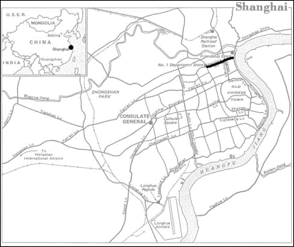
Figure 1

Figure 2
B. The Growth of the Region
1. The Forces Composing the
Urban Texture in the Region
a) The Political Force
The process of a
strategy called “Construction beyond boundaries” [2] wove the city since its
colonial period. In the figure 3, the above zone in yellow is the British
concession, the below in blue is the French zone, both setting out from the
Bund. The colonists just got the permission to settle their homes along the
Bund from the Tsing Dynasty after the 1840s war. To expand their region, the
British built new houses along Nanjing Rd. from the east to the west as their
living and commercial axis. At the same time, they “offset” this main axis to
the both sides in a very short distance offering cheap houses to the local
people without the local government’s permission. Initially the local
government didn’t notice such small construction process. With full filled
residents living in this region supported by the urban facilities offered by
the colonists, the British got the tacit permission to expand their concession
to the north and south, which is called “Construction beyond boundaries”.
As a part of
colonial history, the growth of the city is the result of the expanding forces
of the foreign countries, during which the streets’ patterns of the Tsing
Dynasty were broken into pieces and reconstructed by the strong western
politicians.
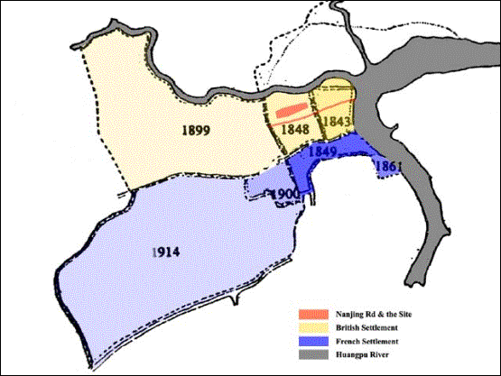
Figure 3
b) The Commercial Force
The main
developing axis Nanjing Rd. got its unique commercial position in Shanghai
naturally. The value of the interface between buildings and streets became an
obvious aspect for the developers to consider. With the born proportion of the
crushed street blocks as the results of the “Construct beyond boundaries” the developers
could pursue the maximum continuous commercial interface in a given region as
showed in figure 4. And actually the north and south interface of the street
blocks in this region became the top commercial streets of the city even the country
at that time. The land price was known as “One inch square one inch gold bar”.
Crushed
Street Blocks Normal Street
Blocks
Figure 4
c) The Traditional Force
The concept of
Feng Shui, which means the location of anything would bring the owner different
fortune has a deep influence on all the construction of Chinese people. It is
why the buildings always face north or south never the east nor west. The
developing of the city Shanghai was also guided by it as a mixture of the western
planning and the local tradition.
2. The Special Urban Texture of
the Region
The combination of
the above forces wove the special urban texture on this region around Nanjing
Rd as we could see in figure 5. The street blocks on the both sides of Nanjing
Rd. are crushed, while the blocks away from it are stepping into the normal
proportion, which is something like the tree’s growth rings from the dense to
the loose. All these urban textures recorded the growth of the city since the
colonial period, which is regarded as the birth of modern Shanghai.
As the
conservation result the old multi-story commercial buildings are still standing
there acting as the volume of the top commercial pedestrian region, while the
new skyscrapers stand behind them. The processing urban revolution hasn’t destroyed
these old buildings because of the good shopping atmosphere they providing
which the skyscrapers can’t. Looking at the figure 6 we could find the
situation of this region. The pressure from the high buildings is there. From
the eagle views the region is like a valley with old low buildings in dense
surrounded by new high buildings in loose.
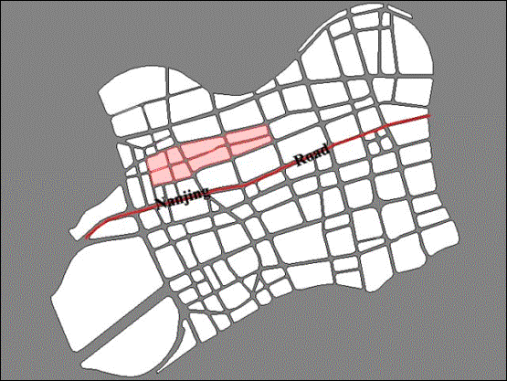
Figure 5
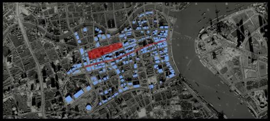
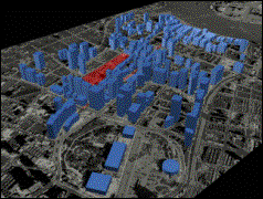
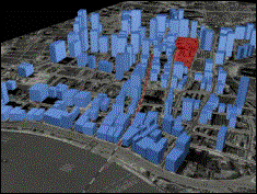
Figure 6
II. The Crossroad
in Front of Urban Planners
A. The Demands from the Booming
Economy
The city of Shanghai
is having an urban revolution based on a booming economy, which could be drawn
from the huge urban construction amount. The investment on the urban
construction in Shanghai from 1990 to 2000 is 310 billion RMB (equal to 38
billion USD). The total exchange amount of the real estate of the city in 2001
was beyond the whole Europe. And the increase is about 33% every year [3]. From
all these figures we could imagine why we called Shanghai a world site
nowadays. The developing model here is very simple, just destroying all the
existing to build a brand new one. Such strategy is based on the demand from a
tight construction schedule, which equals to the profit to the investors. So we
didn’t have time to consider more on the way we are taking. Everything is just
from our instinctive response. What we know best is, “We want good floor area
as many as possible on a given site in a short time as soon as possible, all
which could repay us the most.”
B. The Way We are Taking
With the thinking
above, the investors helped by the designers found the easiest and the seemly
infinite way to get floor area is to combine the crushed street blocks into
bigger one with proper dimensions to build high buildings on it. Such process
is under going now in our site. In figure 7 we could see three streets have
been erased. Then the six crushed blocks have been combined to adapt the
dimension of a new skyscraper. As a result, a part of the urban texture as an
evidence of the city’s growing history has been erased.
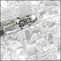
Figure 7
C. Urban Complexity Beyond Two Options in Front
of Planners
It seems
inevitable to destroy the old urban texture to full fill the economic demand to
build skyscrapers. But this decision is just based on one condition that the
floor area demand could only be full filled by the skyscrapers which could
always offer more floor areas than the multi-story buildings. So in front of us
there are two options in urban development as shown in figure 8, to be higher
or to be denser. As we know, on a given site building higher would definitely
get more floor areas than building lower. But the real urban situation is much
more complex. Another aspect “Density” would count a lot. For the reasons of
fire protection and sunshine hours, the high buildings have to stand in a low
density, while the multi-story-buildings could stand shoulder to shoulder in a
very high density. Then with a different density, it would be very difficult to
tell immediately which model, “higher but looser” or “lower but denser”,
provide more floor areas. This is why
we always provide 3 main figures as Total Floor Area, Density and Height Limit,
when we give a development plan to a region. With these figures the further
designers always have a very big design space, in which he could choose to go
higher or denser both having the same construction volume. Here on this
pedestrian site, it is obvious that the denser model could provide a better
shopping atmosphere, much longer commercial interface, and better view from the
bund than the higher model on the condition that the total floor areas the
denser model could offer here could full fill the real market demand. If we
could prove that, it will be a strong beat on the popular building-higher-model
in Shanghai, and a good path to save the historic urban textures under the huge
revolutionary pressure from the economy demand or just an excuse of a
lazybones.
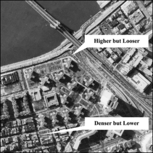
Figure 8
D. The Author’s Defense
The period of
foreign concessions is at least one of the most important parts in the history
of Shanghai, especially in the fields of the city’s construction development
and the city’s culture. As a main growing axis, Nanjing road and the region on
the both sides are the best clues to understand the city. Then the special
urban texture in this region is a lively evidence. So the author believes that
there should be no reason to erase such an important footprint of the city. To
keep it and to full fill the demands from the booming floor area usage, the
author tries to establish that to be denser but lower will be better than to be
higher. To debate on that, he takes the following analysis, and tries to
defense with iron evidence.
III. The Author’s Analysis Aided by GD Concept
A. The Usage of GD Concept
The concept of GD
(Generative Design) is introduced to this analysis. The philosophy in front of
us is revolutionary. The traditional design process is always abstracted as a
loop of generating one solution following a careful evaluation. The quality of
the solution in a limited schedule is decided by the amount of the loops. More
loops would lead to better consideration on more aspects, which is always the
foundation of a better solution. We always regarded that the two parts,
generation and evaluation are the domain of human intelligence. But the GD
concept frees the human brain out of the generation part instead of rapid
computer generated solutions based on some rules, which we used unconsciously
in design process in the past. Then the human brains can focus totally on the
evaluation part. Actually the speed of one loop in the design process is
greatly accelerated by the aide from the computer. Then with more loops we can
raise the design quality. At the same time, the design process is becoming a
selecting process. Maybe in the future, everybody could enjoy the design
process with all the special complex rules and calculation done by a program
[4].
With such a new
concept, we could try to generate building boxes on a site according to any
given parameters such as Total Floor Area, Height Limit and Density with the
layout rules we used to apply on the site. Then the computer could generate
hundreds and thousands of different solutions or we called them samples [5].
Let’s generate 100 samples for each set of parameters. From the view of
statistics, more samples will lead to more accuracy [6]. One designer would
give 1-5 different solutions to a site according to a set of parameters
normally. Then 100-sample is enough to hold all the possibilities of street
space forms on a building-box level (The “building-box level” is the premise of
the following analysis, which means every building is presented as a box of the
same volume). After we adjust the parameters as we planned in the following, we
could get 4 sets of 100-sample which could present all the possibilities and
features of the street space forms on a building-box level of the site in the
planned 4 circumstances. Finally, we could do the visual analysis based on the
features and representative models among these four 100-samples.
In the following we could discover that GD method offers us a path to the rational analysis on the space regulatory parameters in a decision-making stage while the most work could be done on the building-box level.
B. The Factors Considered in the
Experiments
As we mentioned
above, the real site situation is very complex. A pure form without the
consideration on the other factors means nothing. From figure 9, it is clear
that the buildings in the site have to conduct the relationship with the
conservation buildings on the Bund to the east, the atmosphere when people
shopping inside on the streets, the extent of the sunshine disturbance on the
surrounding buildings, and the height’s up and down from an eagle view.
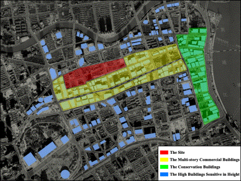
Figure 9
1. The Visual Disturbance on the Conservation Buildings
The government documents need the Bund to be visually
protected. That is to say people should not see anything disharmony on the
skyline of the Bund, when he stands on the other side of the river. In other
words there is a height limit (for our site it is 24 stories) [7], near the
bund being lower while away from it being higher. This could be controlled in
the program to set different height limit. And the result could be examined by
a 3D perspective view on the generated box models.
2. The Visual Harmony while Shopping along the Streets
The commercial atmosphere is usually effected by the
proportion of the street width and the façade height, altogether by the scale
and continuity of the street space. There are a lot of books to introduce the special
figures, which are the results of experiments and observations. Not to be too
dogmatism, we just adopt some rules not the exact figures. Usually continuous
interface and WH proportion between 1:1
to 1:3 will be welcomed by the commercial pedestrian streets. Anyway, we have
the 3D models. With the VR tech we could feel the atmosphere directly.
3. The Sunshine Disturbance on the Surrounding Buildings
The
sunshine hour is a very important figure in Shanghai real estate market. And
the disturbance on the other buildings always limits the design space in a
great extent, especially in such a developed region with a very complex
situation. So in this stage we just use a basic distance formula to keep the
building density in the site.
4. The Heights’ Up And Down of the Region from an Eagle View
As
far as the eagle view from the towers in Shanghai is concerned, we used the VR
again to simulate the perspective views from several important towers such as
Jin Mao Tower. It may be an exciting aspect for the governors to consider.
C. The Four Experiments Designed
for the Rational Comparison
The 4 planned
experiments (see Table 1) are based on the government planning regulations and
the construction experiences with the premise [7] that in this site, the high
buildings would have 18-24 stories; multi-story buildings would have 5-7
stories; for the high ones, “Density” has to be below 70% and “Floor Area Rate”
has to be below 8; for the low ones “Density” has to be below 70% and “Floor
Area Rate” has to be below 4.5.
Then the author
generated 100 samples for each experiment (A-D) with the program HOD.
The operation
steps are introduced in the following.
Step 1. Run
HOD which is programmed in VB6 using the ActiveX interface of ACAD 2004 [8-10].
Step 2. Open
the DWG file of the site containing the red lines and surrounding building
boxes with the thickness representing the heights.
Step 3. Pick
the red lines of the design region in a window selection.
Step 4. Setup
the parameters such as Story Range (low & high), Density, Floor Area Rate
and the others as shown in the figure 10.
Step 5. Click
the button “Generate”. (“100 loops” was set in the program, so it will generate
100 different samples of the whole site with building boxes according to the
above parameters in several seconds. All the results are placed in ACAD Model
Space in another layer. Then we could check it conveniently.)
Step 6. Browse
the samples and pick out 5 typical samples from each experiment to visually
analyze in 3DMAX through several fixed cameras.
The figures
11.1-11.4 for A-D are a part of the eagle views rendered in 3DMAX. And figures
12.1-12.4 for A-D are the street views from the human views.
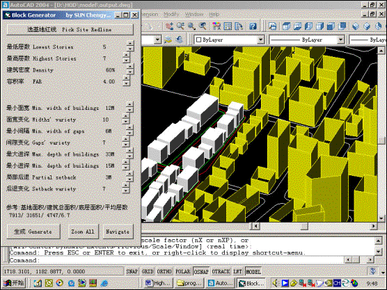
Figure 10
|
Experiment |
A |
B |
C |
D |
|
FAR |
4.0 |
4.5 |
4.5 |
8.0 |
|
Density |
60% |
70% |
19% |
38% |
|
Stories |
5-7 |
5-7 |
18-24 |
18-24 |
|
Notes |
Keep the existing urban texture |
Have to erase five streets |
||
Table 1
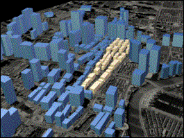
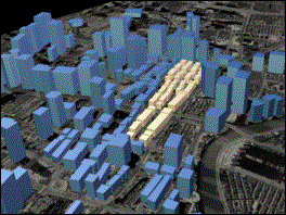
Figure 11.1 Figure 11.2
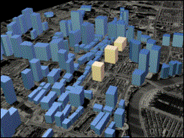
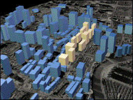
Figure 11.3 Figure 11.4
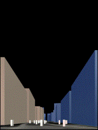
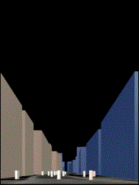
Figure 12.1 Figure 12.2
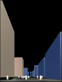
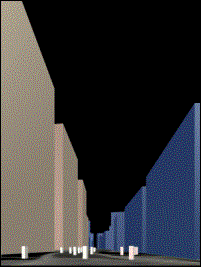
Figure 12.3 Figure 12.4
IV. Conclusion
Based on the
analysis of the generated samples the author found that:
First, it is
impossible for the planners to keep both the skyscrapers and the existing
special urban texture on one site. They have to choose one direction.
Second, the floor
area limit of multi-story building is 225,000 square meters as in sample B
(figure 11.2 and 12.2). At the same time the density is 70%, which could full
fill the real market demand of 180,000 square meters [3].
Third, according
to the conservation height limit and the FAR limit, the density of high
buildings can’t beyond 38% as in the extreme sample D (in figure 11.4 and
12.4), which would lead to a shopping malls model not a pedestrian model.
Fourth, concerning
the continuity as well as the atmosphere of the commercial interface and the
relationships to the opposite buildings on Nanjing Rd. and the people walking
on the pedestrian streets, the visual effect of the sample A and B (in figure
12.1 and 12.2) are much better than in sample C and D (in figure 12.3 and
12.4).
In summary, going
denser is more suitable on this site, which could not only full fill the real
market demand, but also offer the benefits of the urban texture conservation,
better commercial atmosphere and human scale, or we say that it keeps the
quality of this top pedestrian shopping region in Shanghai. At the same time,
the author found that the proper parameters for this site is FAR= 4.0,
Density=60%, Height=5-7 according to the samples, which could offer a good
visual effect and 20,000 square meters.
Wish this
conclusion could contribute to the urban construction on this site in future.
References
[1] Wang, Shaozhou, 1989, The Shanghai Urban
Architectures, Jiangsu Science Publishing.
[2] Wu, Jiang, 1997, The Shanghai Architecture
History in One Hundred Years, Tongji Publishing.
[3] Shanghai Economic Committee, 2003, The
Real Estate Survey, Shanghai.
[4] William J. Mitchell, 1995, City of Bits,
MIT Press.
[5] Goldberg, D. E., 1989, Genetic algorithms
in search, optimization and machine learning, Addison Wesley Publishing.
[6] Feller, W., 1971, An introduction to
probability theory and its applications, New York: John Wiley & Sons
inc.
[7] Shanghai Urban Planning Committee, 2002, The
Regulations of Shanghai Urban Planning, Shanghai.
[8] Holland, J. H., 1962, Outline for a
logical theory of adaptive systems, Journal of the Association for
Computing Machinery.
[9] Howard, Lee M., 1995, The GA-P: A genetic
algorithm and genetic programming hybrid, IEEE Expert.
[10] Michalewicz, Z., 1996, Genetic algorithm +
data structures= evolution programs, New York.