The View
from the Road - the Potential of GPS Technologies
to inform a Generative Approach to
Designing Visual Sequences for the Observer in Motion
Katharine
S Willis, BA(Hons), DipArch, March
e-mail: katharinewillis@hotmail.com
Abstract
This paper proposes a new approach to understanding of how we can create legible cities, through a study on generative approaches to navigation, orientation and identity. A citizen’s understanding of a city is formed in their cognitive memory by paths they take, features that they use to orientate themselves; a conscious sense of the displacements of the body, a mental mapping of the space. In a dynamic environment we are constantly engaged in the attempt to organise our surroundings, to structure and identify them.
Due to the complexity of the urban environment is experienced it has often proved difficult to find suitable technologies which enable human mapping and orientating techniques. GPS is an emergent technology that has the potential to allow us to identify new aspects of journeys and of our surroundings.
The paper will seek to propose the use of GPS to develop a generative approach to exploring navigable, rich urban environments. It will propose that motion through the urban fabric can be enhanced to enable the user to respond dynamically to the city environment where existing human navigation techniques often fail. It will initially seek to outline how an individual understands a city through mapping and orientation. It will then review some projects that successfully engage the motion of the citizen through a space, creating environments which aid way-finding strategies.
The paper will then move on to look into generative methods for developing spatial sequencing that are meaningful. By analysing the patterns, landmarks and paths that individual’s store as memory of place, it will start to define some of these strategies. It will further discuss the validity of starting to map some of the results of these generative strategies back into concepts of urban form.
Wayfinding: Route learning and Memory
The
ability of an individual to navigate in an environment can be broke down into
two categories: procedural and route knowledge. Procedural knowledge is usually
gained by personal exploration of a new area, and is ordered sequentially and
often structured around features such as landmarks.
Meanwhile
survey knowledge is attained through exploration of an environment using
multiple routes, and results in an exocentric metal representation of an area
as a bird’s eye view; a cognitive map. Such navigational awareness is formed by
sequential travel and involves going through a dynamic process of learning
about the environment. The key features that enable people to develop and use
cognitive maps of their environment are:
- Existing survey
knowledge such as maps
- Routes or paths
- Nodes or boundary
points
- Chunking of the
environment into zones
- Landmark
recognition
In
the process of wayfinding the strategic link is the environmental image or
cognitive map as it also referred to, as opposed to a conventional cartographic
map. This is the generalized picture of the exterior physical world that is
held by an individual [1]. They are highly personalised, and different people
develop varying levels of maps.
Paths, Nodes and Landmarks
Paths
are channels along which the observer occasionally or potentially moves. They
may be streets, footpaths, pavements, canals, rivers or railway tracks [2]. For
many people these are the predominant elements in their cognitive maps. People
observe the city whilst moving through it, and long these paths and other
environmental elements are arranged and related. When moving along a path an
individual experiences an organised sequence in which phases follow each other
meaningfully in an order. The critical aspect of this experience is that it is
perceived whilst in motion. In fact observers are aware of, even in remembering
the dynamic quality of a path, the sense of motion along it. Objects or
landmarks along the path can define it more clearly, or heighten the effect of
motion.
The experience of the environment along a path or route also has a sense of spatial sequence. The continuity and rhythm are similar to music or film. But the critical aspect is that vision is the principle sense. The attention of the observer is caught by both near and far objects, such as signs, traffic, the sky, topography and buildings[3]. These form landmarks along the route, by becoming part of the sequential experience of the observer. The observer locates these moving objects and space in a total structure, orientating themselves with regard to the world around them.
GPS Technology
GPS stands for Global
Positioning System, a series of twenty four satellites and receivers that are
capable of listing precise locations. Signals from the satellites are broadcast
at a known interval based on atomic clocks, which are
picked up by GPS receivers. These devices trilaterate the radio wave data and
calculates, to varying degrees of accuracy, the location on Earth. The accuracy
of the positional information can vary from one kilometer down to millimeters.
In order for GPS to function properly, a receiver must be in contact with at
least four satellites to determine a 3D position using latitude, longitude and
altitude.
NAVSTAR Constellation: 51 32
N 0 5 W
____: Aug 02 11:9:27 2004 41¡21'58.56"N
1¡09'58.15"E
Figure 1: raw Satellite
co-ordinate data
The GPS receiver employs an
interface that provides an interpreted format of the satellite data, which is
in essence displays a trace. The record of the satellite positional data
appears at the bottom of each display: the identifying numbers of the NAVSTAR
satellites, the time spent in contact with them and the number of data points
collected by the receiver. The display is based upon a trace; a sequence of
points that registers the movement of the receiver across some physical space.
However GPS receivers also
enables the user to input information. A typical handheld GPS receiver device
has features which include:
- the ability to make a trail map by printing your
waypoints, routes and/or tracks on the map
- display the elevation profile for a track or
route
- make multiple tracks and routes visible
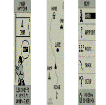
Figure
2: screenshots showing display features of Garmin handheld GPS device [3]
The potentialities for GPS
lie in the fact that the location data requires that both movement (trace) and
inertia (point) be registered so the map-user operates in an layered space.
This transparent layering enables new interpretations and actions of the user, and
consequently offers opportunities for re-visualising spatial cognition. The
elements of architecture such as landmarks, routes, and environment are
transformed and redefined in the interactions of this data. This scale-less
information zone constitutes not simply the representation of a pre-existing
space but another space altogether [4].
Surprisingly, the
possibilities for disorientation are also created, not in the physical
environment but instead in the technology that assures orientation and this throws
open a further set of possibilities. In this situation GPS provides the chance
to map some of these serendipitous actions; the discovery of landmarks and
districts only on approach as if by chance [5].
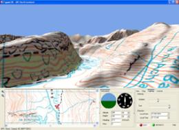
Figure 3: screenshot of Fugawi 3D topographical
GPS mapping software [6]
Generative Navigational Strategies
The
GPS device can be used to map the motion through an environment, whether this
motion be planned or serendipitous. By allowing people access to the mapping of
their environment and where this technology becomes increasingly ubiquitous and
quotodien the physical environment becomes transformed. The resulting GPS data
can be used to enable generative strategies, thus improving the quality of the
sequencing of the environment. It is layered with multiple readings, both
planned and spontaneous, both informed and data poor.
Generative learning takes
place when links are generated between the contents of short-term memory and
our knowledge base, or long-term memory. [7] An individual's memory will
further improve dramatically if some of the to-be-remembered information is
self-initiated. This layered
condition of data generated through the GPS and real world information enables
generative learning through the active integration of new ideas with the
learner's existing mental mapping devices. GPS data, by supporting, enhancing and interacting with the existing
cognitive mapping strategy of the individual, enables them becomes immersed in a
generative learning environment.
Potential for Design of Spatial Sequences
The
multilayered environment, formed through the overlay of cognitive and GPS
mapping strategies is rich, but there exist at the juncture some voids in the
provision of data. These voids prohibit generative strategies since they create
conflicting accounts of the urban environment which cannot be easily
interpreted. These voids can be identified as:
- Where GPS signal is
weak or non-existent at points along the route
- Where the level GPS
accuracy is not sensitive enough to assist the navigational task, and thus
leads to distortion in the data
- Where real
environment is easier to navigate without technological support
- Where conflict
exists in the interpretation of information
- When a user chooses
to switch off GPS display and rely solely on human cognitive mapping
- Where GPS data fails because it lacks a
relational human scale in the immediate physical environment
However
they also present opportunities for the design of spatial sequences for the
observer in motion. Devices and structures can be created that inhabit these
void spaces and enable meaningful generative learning of an environment. These
interventions can either be personalised or generic, but will inevitably
combine to create new topographies.
Conclusion
Cognitive
mapping of the urban environment is the individual’s ability to mentally map a
space, whether it be familiar or unknown. This process, also known as
wayfinding utilises a number of strategies, such as identifying routes,
recognising landmarks, sequencing points or nodes and chunking of the
environment into zones. One of the critical requirements of navigating the city
is to undertake the task whilst moving through it, and to interpret this
experience an organised sequence in which phases follow each other meaningfully
in an order. This paper proposed that motion through the urban fabric can be
enhanced to enable the user to respond dynamically to the city environment
where existing human navigation techniques often fail.
As
an emergent technology, GPS enables an individual to obtain accurate data as to
their location, and to view their movement through the city as a trace display.
It also provides the opportunity for the individual to personalise the
interpretation of this trace, by creating input, which enhances the
information. Through the availability of this information the physical
environment becomes transformed; it becomes effectively overlaid with a data
space. Through the process of feedback and exchanging of data and memories, a
change of the existing notion of time and space which is based on the
linear, static understanding of the world is initiated.
The resulting multi-layered mapping provides the opportunity to utilize generative learning approaches to enhance existing cognitive mapping devices. Generative learning takes place when links are generated between the contents of short-term memory and the individual’s knowledge base. In identifying the junctures between the GPS and cognitive mapping strategies, numerous and rich opportunities for physical interventions in the urban form arise.
References
[1]Appleyard, D, Lynch, K , Myer, JR (1964): The View
From the Road, Cambridge, MA:MIT Press
[2]
Lynch, K. (1960). The Image of the City, Cambridge, MA:MIT Press
[3] http://www.garmin.com
[4]Kurgan, L (1995): You Are Here:
Architecture and Information Flows. Exhibition catalogue, Barcelona: Museu
d'Art Contemporani
[5] Kaasinen, E (2003): User Needs for
location aware mobile services, Personal Ubiquitous Computing 7; 70-79, London:
Springer-Verlag
[6] http://www.fugawi.com
[7] Wittrock, M. C. (1984). Learning as a generative process. Educational Psychologist, 11, 87–95