Virtual landmarks – An Augmented Generative Environment
Katharine S Willis,
BA(Hons), DipArch, March
e-mail: katharinewillis@hotmail.com
Abstract
The artwork develops the potential for visual perception
enabled through a plasticity of bodily representation, and the ability to
access information from remote sites, as applicable to an interface which
responds to navigational tactics. It is an augmented generative environment
that develops a person’s wayfinding tactics through the creation of virtual
landmarks and memory nodes overlayed onto the real city. The augmented
environment is generative, in that it there is a constant feed back loop in the
real space, driven by the cognitive mapping strategies of the user.
Augmented Interfaces
The development of interfaces that accurately simulate three-dimensionality and that are responsive enables the use of experience of real-world environments to be transferred to those of simulated environments. The human perceptive system relies on numerous cues and strategies to give form and meaning to the visual world. The fundamental property of the visual field in the real world is that it is extended in distance and modelled in depth [1] and as such gives an impression of surface and perspective depth. In designing augmented reality environments that appear to overlay on the real world, the image has, to some extent, to assimilate some of the properties of the ‘real’ world in order to interact in a manner that is believable to the eye. This also vital in minimising effects such as vestibular-occular conflict where that which is perceived by the eye conflicts with what is physically experienced.
Spatial
Cognitive Mapping
Spatial cognition concerns the way we acquire, organize, store, and recall information about locations, distances, and arrangements in the physical environment [2].
Environmental images are the result of this two-way process between the observer and his environment. The environment suggests distinctions and relations, and the observer selects, organizes, and endows with meaning what he sees. This organization can be understood as being broken down into three basic aspects: identity, structure and meaning. A workable cognitive map requires first the identification of an object, which implies its distinction from other things, its recognition as a seperable entity. This is called identity. Second, the image must include the spatial or pattern relation of the object to the observer and to other objects. This is called structure. Finally, this object must have some meaning for the observer, whether practical or emotional [3].
However cognitive maps are not two dimensional entities. Since we live in a three dimensional world cognitive maps should reflect the third dimension rather then being just as a two dimensional sketch maps, the "atlas in the head" conceptualization is more suitable than the "map in the head" conceptualization [4].
The artwork draws predominantly on two key aspects of the
concepts identified above. The first being the presence of meaning in the
organisation of the environment, by enabling the user to draw on personal
individual resonances and subsequently identify and recognise their value. The
second aspect is that the artwork is three-dimensional and time based, thus
developing the corresponding spatial and temporal qualities of the ‘atlas in
the head’. In combining the two together the resulting augmented environment is
both meaningful, complex and responsive.
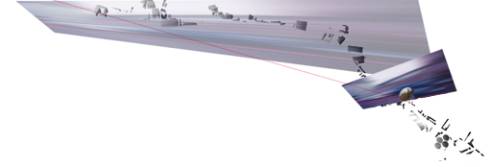
Figure 1: sketch showing trace of physical nodes
along a defined route
Models of Memory
In navigation the individual
relies on cognitive abilities to recall the map at the appropriate moment and
use it to make sense of the environment at the current time and place. In order
to do this the faculty of memory is intrinsic to the process. However an
individual’s memory cannot retain everything; if it could, we would be
overwhelmed with data. Memory is the result of a process of selection and of
organizing what is selected so that it is within reach in expectable
situations. However in this sense
memory is essentially a capacity to retain data that is meaningful and discard
information that has no apparent value [5].
Since the limitations of
short-time memory mean that not all information perceived from a route
description can be stored. An individual learns to identify and remember
information at critical points along the route, such as memory for landmarks at
decision points that require a direction change[6]. Using these strategies,
models of memory can be created that help recall as well as to enabling them to
search or browse through large amounts of information. This information can
then be databased to create what is essentially a catalogue of meaningful
events together with properties associated with them.
The artwork utilizes this
cognitive facility to create a spatial database formed from memory ‘landmarks’
or ‘nodes’. These nodes of information are in effect a cognitive storage
device, defining a chunk of information by its spatial position at a particular
point and time. This allows for more
varied and resonant opportunities for memory retrieval.
The Form of Information
In the artwork a key attribute of the information displayed
is that it is be real world sensitive, and is therefore part of a dynamic time
sensitive system. Since the user has to integrate the display of
computer-generated information with the real world input any display will aim
at extreme efficiency. A spatial
interface rather than a two dimensional window type screen is employed since
this achieves a far greater integration with the spatiality of the real world.
Thus information displayed is linked to three dimensional objects which is
depth cued and obeys the basic laws of location in a three dimensional space
(linear perspective, superimposition, light and shadow and loss of detail with
distance). In the display colour has been used to enable quick and easy
distinguishing of elements. Similarly the use of object metaphors for input
operations means that the user’s mental workload is not increased by trying to
recall the location of data.
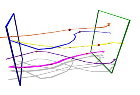
Figure 2:
generation of artwork
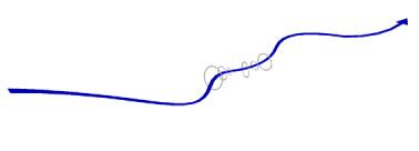
Figure 3:
spline generation of artwork with time indicated by the arrow
Self Generating
The augmented reality interface therefore distinguishes
itself from a real environment in that it enables access to information that is
usually contextually appropriate, but simultaneously does not isolate the user
from the application of such data in the real environment. The interface
supports both visual perception and mental workload by augmenting human
capabilities of structuring and adapting to complex information input. In
creating a prioritisation of information display of data that arises out of
study of the human perceptive systems capabilities, and by providing
information in spatial form the user is able to maximise interpretation of the
environment. Since the process occurs in real time the artwork is a constantly
renewing itself and generating new forms within the database.

Figure 4: stills from artwork
Conclusion
The
artwork utilizes three-dimensional objects that respond as though present in a
three-dimensional world (four if time is considered as a quality). By drawing
on the cognitive mapping abilities of the individual, the route is broken down
into nodes of meaningful information, identified by their spatial location at a
particular point or dynamic sequence in time.
In this way the data nodes come to be considered as virtual landmarks along the route, thus aiding sequential memory processes to be utilised. By literally tagging the user’s time and location of access to information and saving it with an added attribute of time the journey the becomes marked not only with ‘real’ world changes in environment, but also with meaningful augmented environment dynamics.
References
[1] 11. Gibson, J.J (1950).: Perception of the Visual
World, Boston: Houghton Midfflin
[2]Gifford, R. (1987). Environmental Psychology:
Principles and Practice. Massachusetts: Allyn and Bacon
[3]Lynch,
K. (1960). The Image of the City, Cambridge, MA:MIT Press
[4]Kuipers, B. (1983). In Herbert L., Pick Jr. and
Lindo Acredolo (Eds.), Spatial Orientation: Theory, Research, and Application.
New York: Plenum Press.
[5]Lynch, K. (1972). What
Time Is This Place?, Massachusetts: MIT Press
[6]Lee, P. U., Tappe, H. and Klippel, A. (2002). Acquisition of Landmark Knowledge from Static and Dynamic Presentation of Route Maps. Künstliche Intelligenz 4/02: 32-34.